|
 |
|
|

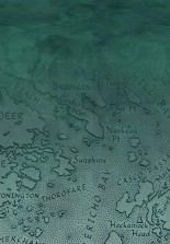
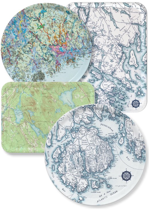
These beautiful map trays are made of birch plywood and manufactured in Finland. A special wedding, housewarming, anniversary, birthday, or hostess gift, each tray is a functional and decorative conversation piece. The maps (Crosen's hand-drawn blue and ocean green coastal maps, along with a selection of vintage USGS topos and a geological map) are printed on melamine and laminated on birch plywood. Sizes and orientation as noted below; see coastal maps on Posters page or email to request design thumbnails. Inventory varies and is limited; Email Jane at jane@mainemapmaker.com (instructions below). Special orders are welcome, but turnaround time may take 4 to 8 weeks or more.
| Casco Bay and the Calendar Islands (ocean tint, large landscape, 12.5" x 16.5") |
$48.00 |
| Casco Bay and the Calendar Islands (ocean tint, medium landscape, 8" x 11") |
$35.00 |
| Small Point to Muscongus Bay (ocean tint, large landscape, 12.5" x 16.5") |
$48.00 |
| Small Point to Muscongus Bay (ocean tint, large portrait, 12.5" x 16.5") |
$48.00 |
| Friendship to Vinalhaven (ocean tint, large portrait, 12.5" x 16.5") |
$48.00 |
| East Penobscot & Blue Hill Bays (ocean tint, large portrait, 12.5" x 16.5") |
$48.00 |
| East Penobscot & Blue Hill Bays (ocean tint, medium landscape, 8" x 11") |
$35.00 |
| Bagaduce Watershed (ocean tint, medium round, 14") |
$48.00 |
| Deer Isle & The Reach (ocean tint, medium round, 14") |
$48.00 |
| Mt. Desert Island & Frenchman Bay (ocean tint, large portrait, 12.5" x 16.5") |
$48.00 |
| Mt. Desert Island & Frenchman Bay (ocean tint, large round, 16") |
$50.00 |
| Orland & Environs (1955 vintage topo, large landscape, 12.5" x 16.5") |
$48.00 |
| Otis & Environs (1942 vintage topo, large landscape, 12.5" x 16.5") |
$48.00 |
| Penobscot Bay to Schoodic Point (1948 vintage topo, large landscape, 12.5" x 16.5") |
$48.00 |
| Hancock County Atlas (Colby's 1881 map, hand-colored, large landscape, 12.5" x 16.5") |
$48.00 |
| Hancock County Atlas (Colby's 1881 map, hand-colored, medium round, 14") |
$48.00 |
| Washington County Atlas (Colby's 1881 map, hand-colored, large landscape, 12.5" x 16.5") |
$48.00 |
| Washington County Atlas (Colby's 1881 map, hand-colored, large portrait, 12.5" x 16.5") |
$48.00 |
| Passamaquoddy Bay & Fundy Isles (ocean tint, large portrait, 12.5" x 16.5") |
$48.00 |
| Passamaquoddy Bay & Fundy Isles (ocean tint, medium round, 14") |
$48.00 |
| Surficial Geology of Downeast Maine (1985 map, full-color, 14" round) |
$48.00 |
To order: First email Jane at jane@mainemapmaker.com about availability of each map tray title and size you would like to order. You'll receive a reply letting you know if the tray is in stock, or can be special-ordered. Confirm by return email, then place your order by choosing the price listed for that size tray. When you get to the Checkout window, type into the Instructions or Comments box the title and size of each tray you are ordering.
| Medium landscape tray |
$35.00 |
|
| Large portrait or landscape tray |
$48.00 |
|
| Medium round tray |
$48.00 |
|
| Large round tray |
$50.00 |
|

Drumlins, eskers, and moraines, oh my! The legacy of the last ice age, Downeast Maine's glacially sculpted landscape, is showcased in this unique laminated plywood tray (shown above, upper left). A colorful conversation piece, it's also a compact lesson in surficial geology, displaying the Downeast portion of the Surficial Geologic Map of Maine on top, with a legend on the back detailing how the various color-coded features were formed.
For example, eskers and kames—ridges of gravel deposited in runoff channels under the melting glacier—are shaded red and gold. Some of the longest eskers in the world are in Downeast Maine, coming together in Columbia's vast outwash plains (shaded pink) like fingers of an outstretched hand.
"As a mapmaker, intrigued by geological patterns in the landscape—lakes, roads (eskers), and hills (drumlins) aligned northwest to southeast with glacial flow, beaches (moraines) and barrens (deltas) aligned southwest to northeast with ice-margin retreat—I got interested in glacial history, and created the tray to inspire fellow explorers to appreciate Downeast Maine's 'ice age trail' landscape."
The surficial geology map, spanning Penobscot, Hancock, and Washington counties, has a glossy finish, while the back of the 14" tray is matte-finished plywood. Enjoy exploring the colorful world of Downeast surficial geology!
|
|
Jane Crosen, Mapmaker, 110 McCaslin Road, Penobscot, ME 04476 jane@mainemapmaker.com
© 2026 |
|
|