|
 |
|
|


 Imagine you're in Hancock County; the year is 1881. With Downeast Maine still in the age of sail, goods are shipped by coasting schooner; people get around in boats, by foot, horse and buggy, stagecoach, steamer, and scow ferry. Coastal towns are bustling with local industries—brickyards, shipyards, water-powered saw and grist mills, fishing, farming, lumbering. Quarries ship granite to markets near and far, and a mining boom is in full swing.
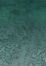
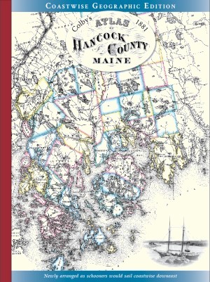
Everyone who loves exploring Downeast Maine, maps, history, old deeds, and genealogy will enjoy using and perusing this remarkably detailed historic Atlas, a fascinating time capsule of Hancock County in the last glow of a 19th-century coastal economy. Compiled and published by George N. Colby in 1881, the original Atlas of Hancock County was drawn in Ellsworth based on actual surveys and then-new U.S. Coast Survey charts, and engraved and printed in Philadelphia; only 350 copies were printed, now a collector's item. The Coastwise Geographic Edition includes all the archival maps arranged in a more geographically consistent layout, updated for today's users with period photos, a preface for historic context, excerpts from an 1878 survey complementing Colby's town profiles, bibliography, and index of historic and current place names. In celebration of Maine's bicentennial and as a Maine mapmaker with deep roots in Hancock County, I'm pleased to keep in print such an important documentation of our Downeast historic cultural landscape.
Imagine you're in Hancock County; the year is 1881. With Downeast Maine still in the age of sail, goods are shipped by coasting schooner; people get around in boats, by foot, horse and buggy, stagecoach, steamer, and scow ferry. Coastal towns are bustling with local industries—brickyards, shipyards, water-powered saw and grist mills, fishing, farming, lumbering. Quarries ship granite to markets near and far, and a mining boom is in full swing.
Everyone who loves exploring Downeast Maine, maps, history, old deeds, and genealogy will enjoy using and perusing this remarkably detailed historic Atlas, a fascinating time capsule of Hancock County in the last glow of a 19th-century coastal economy. Compiled and published by George N. Colby in 1881, the original Atlas of Hancock County was drawn in Ellsworth based on actual surveys and then-new U.S. Coast Survey charts, and engraved and printed in Philadelphia; only 350 copies were printed, now a collector's item. The Coastwise Geographic Edition includes all the archival maps arranged in a more geographically consistent layout, updated for today's users with period photos, a preface for historic context, excerpts from an 1878 survey complementing Colby's town profiles, bibliography, and index of historic and current place names. In celebration of Maine's bicentennial and as a Maine mapmaker with deep roots in Hancock County, I'm pleased to keep in print such an important documentation of our Downeast historic cultural landscape.
Quality paperback with fabric binding, printed in black & white on cream paper with color cover, 74 pages, 12"x 15¾". Maine Mapmaker/Waterbird Press, ISBN 978-1-7346402-0-5. $42.00 retail, available by mail order.

 In 1881, with Downeast Maine still in the age of sail, goods are shipped by schooner; people get around by boat, horse and wagon, stage, steamer, train, and canoe. Machias, Eastport, and Calais are international ports, with St. Croix riverfronts connected by rail. Coastal towns are humming with water-powered mills shipping lumber in schooners built by local shipyards. Along with fishing, farming, and guiding, men work in the lumberwoods, on river drives, and in tanneries. Sardine canneries abound, and quarries ship granite to markets near and far.
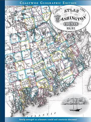
Everyone who loves exploring Downeast Maine, maps, history, old deeds, and genealogy will enjoy using and perusing this remarkably detailed historic Atlas. Based on plans and surveys, the town, village, and lot maps capture a colorful time in Washington County's history, at the height of a 19th-century coastal economy. Compiled and published by George N. Colby in 1881, the original Atlas of Washington County was drawn in Machias, Maine, and printed in Philadelphia; only 300 copies were printed, now a collector's item. The Coastwise Geographic Edition includes all the archival maps arranged geographically for today's users, plus 40 period photos and captions, preface for historic context, excerpts from an 1881 gazetteer complementing Colby's town profiles, bibliography, and index of historic and current place names. In celebration of the new Downeast Maine National Heritage Area designation, I'm pleased to keep in print this important documentation of Washington County's historic cultural landscape.
In 1881, with Downeast Maine still in the age of sail, goods are shipped by schooner; people get around by boat, horse and wagon, stage, steamer, train, and canoe. Machias, Eastport, and Calais are international ports, with St. Croix riverfronts connected by rail. Coastal towns are humming with water-powered mills shipping lumber in schooners built by local shipyards. Along with fishing, farming, and guiding, men work in the lumberwoods, on river drives, and in tanneries. Sardine canneries abound, and quarries ship granite to markets near and far.
Everyone who loves exploring Downeast Maine, maps, history, old deeds, and genealogy will enjoy using and perusing this remarkably detailed historic Atlas. Based on plans and surveys, the town, village, and lot maps capture a colorful time in Washington County's history, at the height of a 19th-century coastal economy. Compiled and published by George N. Colby in 1881, the original Atlas of Washington County was drawn in Machias, Maine, and printed in Philadelphia; only 300 copies were printed, now a collector's item. The Coastwise Geographic Edition includes all the archival maps arranged geographically for today's users, plus 40 period photos and captions, preface for historic context, excerpts from an 1881 gazetteer complementing Colby's town profiles, bibliography, and index of historic and current place names. In celebration of the new Downeast Maine National Heritage Area designation, I'm pleased to keep in print this important documentation of Washington County's historic cultural landscape.
Quality paperback with fabric binding, printed in black & white on cream paper with color cover, 74 pages, 12"x 15¾". Maine Mapmaker/Waterbird Press, ISBN 978-1-7346402-2-9. $45.00 retail, available by mail order. June 2023
Sarah Craighead Dedmon's Washington County Almanac article

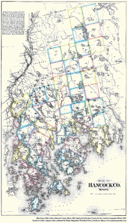 Colby's archival county map from the Atlas of Hancock County, Maine, 1881, hand-colored by Jane Crosen for the front cover of the Coastwise Geographic Edition of the Atlas (see above), is available as a poster. The complete map, cropped to fit the proportions of the newly arranged edition's front cover, seemed too beautiful not to offer also as a print suitable for framing. Printed on smooth poster-quality cream paper, the hand-colored Map of Hancock County measures 13" x 19". $15.95

|
|
|