|
 |
|
|

Map posters include the Coastal series, Lake series, and Parody Charts.
 COASTAL MAPS COASTAL MAPS
The Coastal series includes ten one- and two-color posters of Maine coastal regions, each hand-drawn and beautifully printed in dark blue ink on warm white paper; the two-color designs have a subtle sea-green watercolor tint in water areas. Ranging from 16" x 20" to 18" x 24", these well-researched and artfully drawn maps are a good size for matting and framing as a beautiful and informative addition to your home or boat—and a handy point of reference for explorers comparing notes.

(Click on the title for a low-resolution preview; the actual printed two-color maps have much clearer detail and softer shading and color)
 |
Casco Bay and the Calendar Islands (two-color), $24.95/ea. |
|
|
Small Point to Muscongus Bay (two-color), $24.95/ea. |
|
|
Friendship to Vinalhaven * West Penobscot Bay (two-color), $24.95/ea. |
|
|
East Penobscot and Blue Hill Bays (two-color), $24.95/ea. |
|
|
Mount Desert Island and Frenchman Bay (two-color), $24.95/ea. |
|
|
Deer Isle and The Reach (two-color), $21.95/ea. |
|
|
Penobscot Bay to Schoodic Pt. (one-color), $13.95/ea. |
|
|
Schoodic Point to Roque Bluffs * Machias (one-color), $13.95/ea. |
|
|
Passamaquoddy Bay and the Fundy Isles (two-color), $24.95/ea. |
|
|
Cape Cod & Islands (one-color), $12.95/ea. |
|
|
Portsmouth & Isles of Shoals (one-color), $12.95/ea. |
|
|
Kennebunk Beach to Biddeford Pool (one-color) $10.95/ea. |
|
|
HANCOCK CO. 1881, hand-colored, cream $15.95 |
|
LAKE MAPS
The Lake series includes five hand-drawn one-color maps of Maine lake regions printed in dark blue ink on ash gray parchment. Scenic and recreational points of interest are located on the map with symbols keyed to a "birchbark scroll" legend. Measuring 16" x 20", these simply rendered, well-informed lake maps fit standard-size frames and are a perfect addition to your home or camp.
(Click on the title for a preview)
PARODY CHARTS
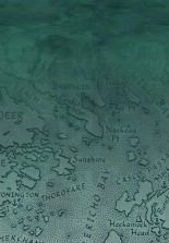
You'll recognize this "highly irregular" coastline once you begin reading some of the place names: Midlife Passage, Boardinghouse Reach, Moot Point, Dire Straits (Sea of Iniquity); Smug Harbor, Darned Shore, Bad Hair Bay, Dunder Head (The Reckless Coast). The product of a long Maine winter (and much poring over maps), these two spoof charts showing neighboring waters will help you navigate your way back to good humor. Framed and on display at home or on your boat, they're sure to bring smiles and hilarity. Each chart measures 16" x 20", printed in dark blue/green ink on warm white paper with a neutral background tint.
(Click on the title for a preview)
|
|
Jane Crosen, Mapmaker, 110 McCaslin Road, Penobscot, ME 04476 jane@mainemapmaker.com
© 2026 |
|
|